Hiking Trails: Torres del Paine National Park
Embark on an unforgettable journey through Torres del Paine National Park, a Patagonian jewel renowned for its dramatic granite spires, glistening glaciers, and turquoise lakes. Hiking here offers a profound connection with nature, challenging your spirit while rewarding you with unparalleled vistas at every turn.
Updated for 2025–2026 Season10 min readOverview
Torres del Paine is a hiker's paradise, offering everything from challenging multi-day treks like the 'W' and 'O' circuits to accessible day hikes suitable for all fitness levels. The park's diverse landscapes feature towering mountains, ancient forests, expansive pampas, and unique wildlife. Prepare for unpredictable Patagonian weather, which only adds to the adventure and rugged beauty of this incredible destination.
Torres del Paine National Park offers a wide range of hiking difficulties. Many iconic trails, such as Mirador Base Torres and sections of the W Trek, are physically demanding, requiring good fitness and stamina for significant elevation gains and distances. However, there are also numerous easier, shorter walks like Salto Grande, suitable for families or those seeking less strenuous exploration. Regardless of difficulty, preparation for varied terrain and rapidly changing Patagonian weather is crucial.
Trails
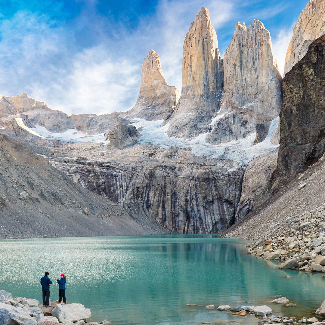
Mirador Base Torres
hardout-and-backPermit RequiredDistance
19 km
Elevation Gain
+800m
Duration
8-10 hours
Type
out-and-back
This iconic hike leads to the base of the three granite towers, offering breathtaking views of the glacial lake and impressive granite spires. It is a challenging full-day trek that rewards hikers with one of Patagonia's most famous panoramas.
Highlights
Waypoints
Refugio Torre Central
0 km from start · +0m · 0 hours
The starting point for many, located at the entrance to the Ascencio Valley, often reached by shuttle from Laguna Amarga.
Refugio El Chileno
5.5 km from start · +400m · 2h 30min
A key rest stop and campsite, marking roughly the halfway point to the base of the towers, with basic facilities.
Campamento Torres
8 km from start · +600m · 4h 30min
The last campsite before the final ascent. This is where the forest gives way to the rocky moraine.
The Moraine
8.5 km from start · +750m · 5h 15min
A steep, boulder-filled section requiring careful foot placement, leading up to the final viewpoint.
Base Torres Lookout
9.5 km from start · +800m · 6h 0min
The spectacular reward: a glacial lake reflecting the towering granite spires of the Torres del Paine.
- • Layered clothing (including waterproof and windproof outer shell)
- • Sturdy waterproof hiking boots
- • Daypack (20-30L)
- • Water bottles/hydration pack (2L+ capacity)
- • High-energy snacks
- • Sunscreen and sunglasses
- • Hat and gloves
- • Trekking poles (highly recommended for descents)
Permit Required: Yes — An entrance fee for Torres del Paine National Park is required, payable online or at park gates. This fee covers park access but does not include camping or refugio stays, which must be booked separately and in advance. No separate trail permit is needed for day hikers.
Trailhead Access: The trailhead is near Refugio Torre Central in the Ascencio Valley. Most visitors take a shuttle from the Laguna Amarga park entrance to the Welcome Center, then another shuttle or walk to the actual trailhead. Renting a car provides direct access to Hotel Las Torres parking, significantly reducing reliance on park shuttles.
Water Availability: Water is generally available from streams along the trail, but always filter or purify. Water can also be purchased at Refugio El Chileno.
Camping Options: Camping is available at Refugio Torre Central, Refugio El Chileno, and Campamento Torres. All camping and refugio stays require advance reservations, especially during peak season.
Best Months: October, November, December, January, February, March, April
Mirador Grey (from Paine Grande)
moderateout-and-backPermit RequiredDistance
22 km
Elevation Gain
+500m
Duration
7-9 hours
Type
out-and-back
A classic section of the W Trek, this trail leads to spectacular views of Glacier Grey and the floating icebergs on Lago Grey. It offers diverse landscapes ranging from enchanting forests to open plains and rocky shores.
Highlights
Waypoints
Paine Grande Refugio
0 km from start · +0m · 0 hours
The starting point for this segment, accessible by catamaran across Lago Pehoé.
Laguna Los Patos
3 km from start · +50m · 1h 0min
A serene lake passed early in the hike, offering views back towards Paine Grande.
Guardería Grey
8 km from start · +200m · 2h 45min
A ranger station and an important point for information and a brief rest before continuing.
Playa Guardería Grey
9 km from start · +250m · 3h 15min
A beach area providing first glimpses of Lago Grey and distant icebergs.
Mirador Glacier Grey
11 km from start · +300m · 4h 0min
The main viewpoint offering expansive vistas of the massive Glacier Grey and its calving front.
- • Layered clothing (waterproof and windproof)
- • Sturdy waterproof hiking boots
- • Daypack
- • Water and snacks
- • Sunscreen and sunglasses
Permit Required: Yes
Trailhead Access: The starting point, Refugio Paine Grande, is reached by a catamaran crossing Lago Pehoé from Pudeto. Pudeto is accessible by public bus services from Puerto Natales or by private car (with parking available). Renting a car offers convenience for reaching Pudeto.
Water Availability: Streams are available along the trail; filtering or purifying is recommended. Water can also be refilled at Refugio Grey.
Camping Options: Camping and refugio accommodation are available at Refugio Paine Grande and Refugio Grey. Advance reservations are essential, especially during peak season.
Best Months: October, November, December, January, February, March, April
French Valley Lookout (Valle del Francés)
hardout-and-backPermit RequiredDistance
20 km
Elevation Gain
+700m
Duration
7-9 hours
Type
out-and-back
Considered one of the most beautiful sections of the W Trek, this hike ascends into the heart of the Paine Massif, offering panoramic views of hanging glaciers, granite peaks, and the impressive 'Frenchman's Wall'. Expect stunning vistas and the sound of avalanches.
Highlights
Waypoints
Paine Grande Refugio
0 km from start · +0m · 0 hours
The starting point for the French Valley segment, accessible by catamaran from Pudeto.
Campamento Italiano
7.5 km from start · +150m · 2h 30min
An unmanned campsite where trekkers often leave larger backpacks before ascending into the valley. Basic facilities are available.
Mirador Francés
10 km from start · +450m · 4h 0min
The first major viewpoint in the valley, offering spectacular views of the hanging glaciers and the Paine Grande massif.
Mirador Británico
13 km from start · +700m · 6h 0min
The ultimate viewpoint (optional extension, adds significant distance/gain) with a 360-degree panorama of the entire French Valley and its surrounding peaks.
- • Layered clothing (waterproof and windproof)
- • Sturdy waterproof hiking boots
- • Daypack
- • Water and high-energy snacks
- • Sunscreen
- • Trekking poles (very useful for the steep ascent)
Permit Required: Yes
Trailhead Access: This trail begins from Refugio Paine Grande, which is reached by a catamaran service across Lago Pehoé from Pudeto. Pudeto can be accessed by public bus or private car, with parking facilities available. Renting a car provides flexibility to reach Pudeto.
Water Availability: Numerous streams flow through the valley; filtering or purifying water is recommended. No potable water points are available beyond Campamento Italiano.
Camping Options: Camping is available at Campamento Italiano (unmanned, reservations mandatory for camping) and Refugio Paine Grande. All camping and refugio stays require advance reservations.
Best Months: October, November, December, January, February, March, April
Salto Grande & Mirador Cuernos
easyout-and-backPermit RequiredDistance
5 km
Elevation Gain
+50m
Duration
1.5-2 hours
Type
out-and-back
A shorter, easier walk offering magnificent views of the turquoise Salto Grande waterfall connecting Lago Nordenskjöld and Lago Pehoé, culminating in an impressive viewpoint of Los Cuernos del Paine. Ideal for those seeking stunning views without a strenuous climb.
Highlights
Waypoints
Salto Grande Parking Lot
0 km from start · +0m · 0 hours
The convenient starting point for this easy walk, with ample parking space.
Salto Grande Waterfall
0.5 km from start · +10m · 0h 10min
The powerful, beautiful waterfall where Lago Nordenskjöld empties into Lago Pehoé, known for its intense blue color.
Mirador Cuernos del Paine
2.5 km from start · +50m · 0h 45min
A breathtaking viewpoint offering direct, close-up vistas of the distinct granite and sedimentary layers of Los Cuernos (The Horns).
- • Comfortable walking shoes
- • Light jacket (windproof recommended as it can be very windy)
- • Water bottle
- • Camera
Permit Required: Yes
Trailhead Access: Easily accessible by car, with a dedicated parking lot near Salto Grande. Public buses also stop at the nearby Pudeto station, requiring a short walk to the trailhead. Car rental is highly recommended for ultimate flexibility to visit this and other easily accessible viewpoints.
Water Availability: No natural water sources along this short trail; please bring your own water.
Camping Options: No camping directly on this trail. Closest accommodations are Refugio Pudeto or the Explora Patagonia hotel nearby.
Best Months: October, November, December, January, February, March, April
Drive to the Trailhead
Browse Car RentalsPlan Your Hiking Trip
Get a personalized packing list for your trail adventure. Never forget essential gear again.
Build My Packing ListSafety Tips
- 1Always check weather forecasts before heading out; Patagonian weather can change rapidly and unpredictably.
- 2Carry sufficient water, high-energy snacks, and extra layers of clothing, including waterproof and windproof gear.
- 3Inform someone of your hiking plans and expected return time, especially for longer or less-trafficked treks.
- 4Stay strictly on marked trails to protect the fragile ecosystem and for your own safety; off-trail hiking is prohibited.
- 5Be aware of strong Patagonian winds; brace yourself and use trekking poles for stability.
- 6Practice Leave No Trace principles: pack out everything you pack in, and respect wildlife.
- 7Carry a comprehensive first-aid kit and know how to use its contents.
- 8Be cautious around rivers and streams, especially after heavy rain, as water levels can rise quickly.
Emergency Contacts
Rescue Service
136 (Chilean Mountain Rescue / CONAF)
Park Rangers
+56 61 223 8887 (CONAF Torres del Paine)
Nearest Hospital
Hospital Clínico Magallanes (Punta Arenas, approximately 3 hours drive from the park)
Before you hit the trail: Torres del Paine National Park
🥾 More Hiking Trails
📋 Practical Info for Torres del Paine National Park
Explore Torres del Paine National Park
More guides for this destination
Drive to the Trailhead
Rent a car to access the best hiking trails near Torres del Paine National Park
Explore More
Discover more guides and resources for this destination
Destination Guide
Planning
Best Time to Visit
Best Time to Visit Torres del Paine National Park 2026 — Month-by-Month Guide
How to Get There
How to Get to Torres del Paine National Park 2026 — Flights, Driving & Transport
Budget Guide
Torres del Paine National Park on a Budget 2026 — Costs, Tips & Money-Saving Guide
Seasonal Guide
Autumn in Torres del Paine 2026 — Weather, Activities & Tips
Seasonal Guide
Spring in Torres del Paine 2026 — Weather, Activities & Tips
Seasonal Guide
Summer in Torres del Paine 2026 — Weather, Activities & Tips
Seasonal Guide
Winter in Torres del Paine 2026 — Weather, Activities & Tips
Travel Tips
Essential Travel Tips for Torres del Paine National Park (2026)
Where to Stay
Where to Stay in Torres del Paine National Park (2026) — Neighborhoods & Hotels
Weather & Climate
Torres del Paine National Park Weather Guide (2026) — Monthly Climate, Temperatures & Best Time
Adventures
Activities
Glacier Trekking in Torres del Paine 2026 — Best Spots, Tips & What to Expect
Activities
Hiking in Torres del Paine 2026 — Best Spots, Tips & What to Expect
Activities
Horse Riding in Torres del Paine 2026 — Best Spots, Tips & What to Expect
Activities
Photography in Torres del Paine 2026 — Best Spots, Tips & What to Expect
Camping Guide
Camping in Torres del Paine National Park 2026 — Campsites, Tips & Gear Guide
Day Trips
Best Day Trips from Torres del Paine National Park 2026 — Distances & Driving Guide
Hidden Gems
Hidden Gems in Torres del Paine National Park (2026) — Secret Spots & Local Tips
Family Guide
Family Travel Guide to Torres del Paine National Park (2026) — Kid-Friendly Tips
Culture & Nature
Food Guide
Food Guide: Torres del Paine National Park 2026 — Local Cuisine & Restaurants
Wildlife Guide
Where to See Andean condor in Torres del Paine 2026 — Guide & Best Spots
Wildlife Guide
Where to See Flamingo in Torres del Paine 2026 — Guide & Best Spots
Wildlife Guide
Where to See Foxes in Torres del Paine 2026 — Guide & Best Spots
Wildlife Guide
Where to See Guanaco in Torres del Paine 2026 — Guide & Best Spots
Wildlife Guide
Where to See Huemul Deer in Torres del Paine 2026 — Guide
Wildlife Guide
Where to See Pumas in Torres del Paine 2026 — Guide & Best Spots
Photography Spots
Best Photography Spots in Torres del Paine National Park 2026 — Locations & Tips
Road Trips
Car Rental
Car Rental in Torres del Paine National Park 2026 — Prices, Tips & Road Guide
Road Conditions
Road Conditions in Torres del Paine National Park (2026) — Driving Guide & Fuel Stations
Driving Routes
Driving from El Calafate to Torres del Paine 2026 — Road Guide, Distance & Tips
Driving Routes
Driving from Puerto Natales to Torres del Paine 2026 — Road Guide, Distance & Tips
Driving Routes
Driving from Punta Arenas to Torres del Paine 2026 — Road Guide, Distance & Tips
Road Trip Itineraries
14-Day Complete Patagonia Road Trip — Complete Itinerary 2026
Road Trip Itineraries
21-Day Patagonia Grand Tour — Complete Itinerary 2026
Road Trip Itineraries
4-Day Torres del Paine W-Trek — Complete Hiking Itinerary 2026
Road Trip Itineraries
6-Day Puma Tracking in Torres del Paine — Wildlife Safari 2026
Road Trip Itineraries
7-Day Photography Masterclass Patagonia — Photo Trip Itinerary 2026
Road Trip Itineraries
7-Day Torres del Paine & El Calafate Road Trip — Complete Itinerary 2026
Road Trip Itineraries
8-Day Torres del Paine & Ushuaia — Tierra del Fuego Itinerary 2026
Compare
Destination Comparison
Best Hiking: Torres del Paine vs El Chaltén 2026 — Trail-by-Trail Comparison
Destination Comparison
Budget Patagonia: Chile vs Argentina 2026 — Where Your Money Goes Further
Destination Comparison
Camping vs Hotels in Patagonia 2026 — Which Accommodation Style Is Right for You?
Destination Comparison
Cerro Castillo National Park vs Torres del Paine 2026 — Which Is Better for You?
Destination Comparison
Chilean Patagonia vs Argentine Patagonia 2026 — Which Is Better for You?
Destination Comparison
El Calafate vs Torres del Paine 2026 — Which Is Better for You?
Destination Comparison
El Chaltén vs Torres del Paine 2026 — Which Is Better for You?
Destination Comparison
Northern Patagonia vs Southern Patagonia 2026 — Which Region Should You Visit?
Destination Comparison
Patagonia First-Time vs Returning Visitors 2026 — What to Do Each Time
Destination Comparison
Patagonia for Families vs Couples 2026 — Best Destinations by Travel Group
Destination Comparison
Patagonia in 1 Week vs 2 Weeks 2026 — How to Plan the Right Trip Length
Destination Comparison
Perito Moreno Glacier vs Grey Glacier (Torres del Paine) 2026 — Which Is Better for You?
Destination Comparison
Self-Drive vs Guided Tour in Patagonia 2026 — Which Travel Style Fits You?
Destination Comparison
Patagonia in Summer vs Patagonia in Winter 2026 — Which Is Better for You?
Destination Comparison
Torres del Paine vs Bariloche 2026 — Which Is Better for You?
Destination Comparison
Torres del Paine vs Los Glaciares (El Chaltén) 2026 — Which Is Better for You?
Destination Comparison
Torres del Paine vs Perito Moreno Glacier 2026 — Which Is Better for You?
Destination Comparison
Torres del Paine vs Tierra del Fuego 2026 — Which Is Better for You?
Destination Comparison
Ushuaia vs Torres del Paine 2026 — Which Is Better for You?
Destination Comparison
W Trek (Torres del Paine) vs O Circuit (Torres del Paine) 2026 — Which Is Better for You?
Explore More Guides
View all →Hiking Trails in Aluminé (2026) — Best Hikes, Difficulty & Maps
Hiking Trails in Carretera Austral (2026) — Best Hikes, Difficulty & Maps
Hiking Trails in Caviahue-Copahue (2026) — Best Hikes, Difficulty & Maps
Hiking Trails in Cerro Castillo National Park (2026) — Best Hikes, Difficulty & Maps
Hiking Trails in Chaitén (2026) — Best Hikes, Difficulty & Maps
Hiking Trails in Chile Chico (2026) — Best Hikes, Difficulty & Maps
Frequently Asked Questions
Do I need to book accommodation or campsites in advance for the multi-day treks?
Yes, absolutely. Camping and refugio reservations are mandatory for multi-day treks (like the W or O Circuit) and must be made several months in advance, especially during the peak season (December-February), as spaces fill up quickly. You will not be allowed to start a multi-day trek without confirmed reservations.
What is the best way to get to Torres del Paine National Park?
The nearest major airports are Punta Arenas (PUQ) and Puerto Natales (PNT). From either city, you can take a public bus directly to the park gates (Laguna Amarga or Pudeto). Renting a car in Puerto Natales offers the most flexibility for exploring various trailheads and viewpoints within the park at your own pace.
What kind of weather should I expect in Torres del Paine?
Patagonian weather is notoriously unpredictable. Expect all four seasons in a single day: sunshine, strong winds, rain, and even snow, even in the middle of summer. Layered clothing, including waterproof and windproof outerwear, is absolutely essential regardless of the season.
Are there any entrance fees for Torres del Paine National Park?
Yes, there is an entrance fee for the national park, which can be paid online in advance (recommended) or at the park entrances (subject to availability). The fee is typically valid for a specified number of consecutive days.
Is it safe to hike alone in Torres del Paine?
While many trails are well-trafficked, it's generally safer to hike with a companion, especially on longer or more challenging routes. If hiking alone, always inform park rangers or your accommodation of your plans and estimated return time, and stick to well-marked trails. Be particularly mindful of strong winds and rapid weather changes.
What wildlife might I see during my hikes?
Torres del Paine is home to diverse wildlife, including numerous guanacos (a type of llama), Andean condors, foxes, and various bird species. While rare, keep an eye out for pumas, especially at dawn or dusk. Always maintain a respectful and safe distance from all animals.
Are trekking poles necessary for hiking in Torres del Paine?
While not strictly necessary for all trails, trekking poles are highly recommended, especially for challenging hikes like Mirador Base Torres or sections of the W/O treks. They provide stability on uneven terrain, reduce impact on your knees, and help with balance in strong winds.
Can I bring my own food into the park?
Yes, you can bring your own food into the park. This is a common and cost-effective way to manage meals, especially for multi-day treks. However, cooking is generally only permitted at designated campsites, and campfires are strictly forbidden in the park due to high fire risk.